
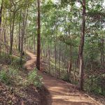
PICK OF THE WEEK – NOT FOR THE FAINT-HEARTED Mt Coot-tha’s Best – There are the Springwood stairs of death and the Urban stairs of death, but if you want some tough tracks, you’ll head to Mt Coot-tha. Over the years, the Brisbane City Council has constructed an increasing number of official tracks on Mt Coot-tha so that all the trails listed here are linked together. It is possible to do each trail on its own, often heading up one way and down another less steep trail to where you started. But you can push on to the start of the next trail as well. The total length of the walk linking all these steep trails together would be over 20 km. For people looking to get fit and build up hiking or trail running fitness, this is a great option. Other people might drive between different trail starts or just do a limited section. Read More about the Lookout Trail, the Powerful Owl ( the old Telegraph Track), Citriodorra Trail, Kokoda, Spotted Gum, Scorpion and Mahogany Trails below.
Buying and selling homes are not for the faint-hearted either! Conveyancing Home will help make your transaction effortless! We also speak Mandarin, Japanese, Spanish & Portuguese, and offer Conveyancing from*$550. Call 073236 2852 or see https://conveyancinghome.com.au/instant-quotes/ #stairsofdeath #mountcootha #trails #homepurchase #conveyancing *Some conditions may apply. Read more at https://conveyancinghome.com.au/instant-quotes/
Mt Coot-tha’s Best One of the best places to start is the Lookout Trail. This is a 1.5 km track that runs up to the Summit. There are lots of ways to access this trail but if you start at the end of Caladenia Street, it gives you a short walk on flatter paths to warm up and stretch your legs. You can also walk from the Brisbane Botanic Gardens following the left fork of the Citriodora Trail until you get to the start of the Lookout Trail.


The Lookout Trail is an easy pleasant walk that rises steeply and averages over the distance are probably the steepest track in Mt Coot-tha. It is also not covered in loose gravel like some other paths, making it more pleasant to walk up. As the top of the Lookout Trail is closed, you must divert onto an easier path to arrive at Mt Coot-tha’s Summit
Returning to your starting point, should you not wish to go down the Lookout Trail, is either by the Spotted Gum Trail or you follow the Mahogany Trail halfway, then cross the road and follow the Citriodora Trail. If you started at the Botanic Gardens, you have the option of several buses from the summit to take you back down.
The newest track on the list, it is one of the less well-known. If you are just doing this track on its own, you can get to the start from either the Honeyeater Track, then divert onto the Reservoir Trail and the Kamala Trail to the turn-off to the Scorpion Trail. Or you can start at the trailhead on Greenford Street, turning right onto the Kamala Trail. If you have just completed the Lookout Trail, then head get there by heading down the Honeyeater Trail and turning off onto the Reservoir Trail.
This is a reasonably steep track that starts off with a medium slope and gets steeper are you get near the top. It is not as steep as the Lookout Trail but the track undulates. This means you go up a steep section and then it dips or levels out. All the newer tracks are designed this way to capture and divert water runoff to prevent erosion in the rain.
When you get to the top of the track you are at the road, and to your left across the road is the Gold Mine Picnic area. There are seats, shelters, water taps and barbecues here. To get back to where you started from, you either turn right and follow the Litchfield Trail to The Summit and down the Honeyeater Track or turn left and follow the leftmost track till you get to the Powerful Owl Trail and across the road, you will see the start of the Jacksonia Track, which takes you down to the Bellbird Trail and then back to Greenford Street.
The most well-known steep track at Mt Coot-tha is the Kokoda Trail, and yes, the last part of this track is indeed the steepest on the mountain. Most people will just park at Greenford Street and walk straight up from there. If you have just completed the Scorpion Trail, then walk back down the Jacksonia Track, then follow the Bellbird Track to the start of Kokoda.
This trail starts off easy getting progressively steeper. Luckily only the last part is very steep. Like a lot of other steep tails, it undulates, meaning your get steep parts followed by flat areas or dips. Even worse it is covered in gravel, making it slippery. As you approach the end of the trail, you will see several side tracks that are less gravelly and a little easier to walk. By a little easier, I don’t mean easy, I just mean, not quite as hard as the main trail.
Kokoda ends up opposite the Channel Nine building and the start of the Powerful Owl Trail. Just to the left of the top of the Trail is the start of the Jacksonia Track, which takes you back down to the Bellbird Trail and then back to the start of the walk.
The most popular steep walk, the Powerful Owl Trail, is probably one of the oldest, and many older locals still refer to it as the Telegraph Track. If you just want to walk this track then there is parking at the Silky Oak Picnic Area and near the entrance to the Simpsons Falls Picnic area. If you have just completed the Kokoda or Scorpion Trails, then you start down the Powerful Owl Trail from the far end but divert onto the Eugenia Circuit down to Simpsons Falls, walk down to the picnic area, and out to the start of Powerful Owl.
When it comes to steep tracks, Powerful Owl is not that steep but it is still a great workout and is easier than the trails listed above. In fact, it is just the right level of steepness to give you a good workout.
You don’t need to walk the entire track. Most of the steep uphill section is over when you get to the start of the Pinnacle Track that leads down to the left. This is the quickest way back, especially if you follow the left branch of this trail. Alternatively, you can keep going, and there are still further areas of the steep track until you get to the tracks on the right leading to the Eugenia Circuit and down to Simpsons Falls. You can keep going to the end of the trail and follow the Super Summit Circuit around back to the start of the walk.
If you had started at the Lookout Trail, you would need to walk to the end of the Powerful Owl Trail, walk the Ghost Hole Track (or the alternative one if that is closed), and then the Litchfield Track back to the Summit. Then it is a matter of choosing which track you want to follow down to the start of the Lookout Trail.
Maculata Track & Spotted Gum Tracks: Honourable Mentions
Maybe you have read the trail descriptions and are busy stretching ready to tackle a trail or two. Or maybe you want to try something but these sound a little too hard. That is okay, here are 2 honourable mention tracks that are suitable for anyone with a reasonable level of fitness to get started on.
The Spotted Gum Track has been constructed from the Brisbane Botanic Gardens up to The Summit. It is really not that hard for most people because even though there are lots of steps, there are lots of flat parts as well. Definitely one of the most popular walks up the mountain. Just some of the many stairs on the Spotted Gum Track that leads from Brisbane Botanic Gardens to The Summit
The lesser-known Maculata Track runs from the far side of the Mountain up to Simpsons Falls. Well, strictly speaking, it takes you up to the road, and on the other side, there is the Stringybark Track that leads to Simpsons Falls. There are lots of steps coming up the far side and gives you a nice workout without being too hard.
Overall
Mt Coot-tha is a great place for people who are trying to build up fitness, especially hiking fitness, to go. Many people knock out a quick 10 kms in the morning before work or in the evening after work with headlamps . Fitness freaks do 20 kms across multiple trails on a weekend before the weather gets too hot. Others just do a quick run up and down the mountain using one of these trails.
But whatever your fitness level and time constraints, Mt Coot-tha is the right spot to find a short or long, easy or steep track to work on your fitness. Plus you can get coffee, cake and ice cream afterwards at The Summit, the Botanic Gardens or at the caravan near the entrance to the JC Slaughter Falls Picnic Area.
With kind thanks, Roy Chambers